
You can download a PDF of the overland Silk Roads and maritime Silk Routes map here. All maps are designed by Paul Oram with input by Elena Paskaleva and Michael Turner.
A Short history of the Silk Roads
The rich history of the region we define as Central Asia is closely intertwined with the so-called Silk Roads, the proverbial pre-modern highway of global interactions connecting the ancient empires of East and West. Though a network of trade routes has been flourishing in this area for a long time, the term Silk Road is a 19th-century invention of the German geographer, Ferdinand von Richthofen. It was an immediate hit and the romantic connotations of the Silk Roads still continue to inspire travellers, traders and governments. A recent example is China’s New Silk Road initiative, a trade and development strategy that started in 2013 as OBOR, ‘One Belt One Road’, and has been renamed the Belt and Road Initiative in 2016. This initiative demonstrates the growing importance of Central Asia as a focal point of geopolitical interests and global ambitions of world powers. Another testimony of the perennial success of the term ‘Silk Road’ is the 2015 bestseller of Peter Frankopan, entitled The Silk Roads: A New History of the World. In this work, Frankopan makes a strong case for a less Eurocentric approach to global history, following in the footsteps of a number of other historians who have argued the centrality of Central Asia in world history.
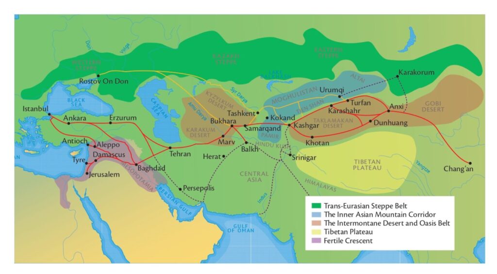
The Silk Roads were a network of trade routes that connected oases, cities and ports over time. The overland Silk Roads and maritime Silk Routes were defined by the different climate and geographical zones of the region. The northern summer roads and the southern winter roads were determined by the complex geography of Central Eurasia, its eastern and western edges. The East-West maritime patterns were determined by the monsoon winds through the Indian Ocean. Inhospitable terrains and climates, as well as political instability, were important factors in the constant evolution of the Silk Roads. This is a composite map that identifies the major cities and ports threaded on these paths and the natural features that inherently determined their patterns.
Geographical zones along the Silk Roads. Download map
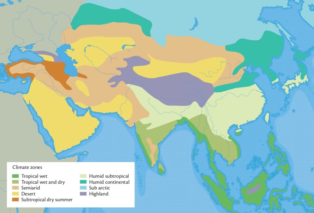
Climate zones of the Silk Roads. Download map
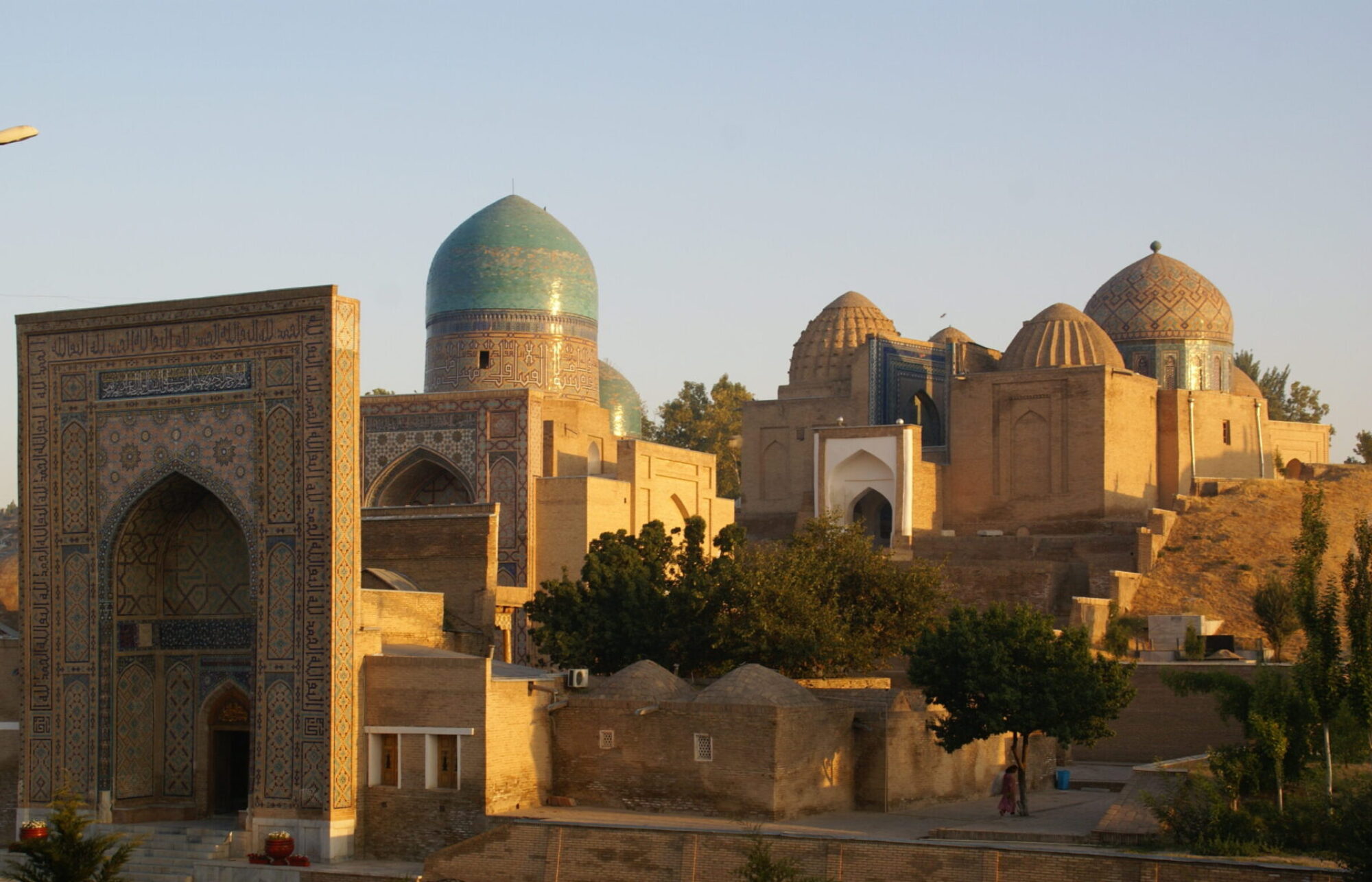
The overland Silk Roads and maritime Silk Routes were also dependent on the governance and political powers of the empires that ruled the vast area of Central Asia. Their heritage is large and varied. On this website we focus on the legacy of the rulers with Turkic nomadic descent who established large empires in the Middle East and Central Asia between the 11th and 14th centuries. The architectural section on our website introduces you to their material culture and built heritage.
The three-part UNESCO Thematic Collection of Cultural Exchanges along the Silk Roads:
Architecture, Monuments and Urbanism offers an overview of major cities and ports.
The tradesmen would usually not accompany the goods all the way from the most eastern parts of Asia to the most western parts of Europe or Africa. Instead, goods would be exchanged numerous times along the way. Silk was only one of the commodities that circulated along the many trade routes that connected the different parts of Asia with Europe and Africa. Other goods included a variety of textiles and furs, spices, precious stones, cattle, horses and pottery. Slaves, such as soldiers, craftsmen and concubines, would also be taken extensive lengths along the Silk Roads to be put to work far from their homes.
The Silk Roads had many advantages to offer and were very lucrative for those involved. They also had certain downsides. The first global pandemic -Black Death- spread effectively along the Silk Roads. Additionally, the advantages of controlling the trade routes, was very much sought after and that meant that war was always around the corner.